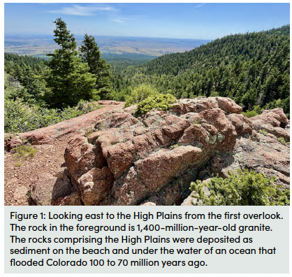
The first mile of the Bartlett Trail is a steady incline through the forested foothills of the Wet Mountains. After about 600 feet of elevation gain, the trail reaches a couple of switchbacks and enters an open area that rewards your climb with the first grand view of Southern Colorado’s High Plains below (Figure 1). The interface between the High Plains and the Rocky Mountains is one of the most dramatic geographic juxtapositions in the United States.
The High Plains earned their name due to their unusually high elevation compared to most plains located right next to mountain ranges. Think of the Cascades of the Pacific Northwest, or of the Andes in Chile — the mountains themselves are high, but as you exit them, the elevation is not far above sea level. The Colorado Rockies are unique in that when you stand in places like La Veta, Walsenburg, or Denver, although you are on the plains, not in the mountains, you still stand over a mile above sea level.
Geologists debate why the High Plains are so high, but there are a few explanations we can rule out. Most famous mountain ranges are formed at the boundaries of tectonic plates, where one of two things happens. As two continental plates crash into one another, one slab of rock is stacked atop the next along faults, building a grand mountain range, like the Himalayas, in the process. Alternatively, if one plate consists of oceanic material, it will sink below the other plate, melting as it descends into Earth’s hot interior, where it melts, forming magma that rises buoyantly like a hot air balloon. The magma erupts in mighty volcanoes, like Mount Rainier or Mount Saint Helens in the Cascade Range. This type of tectonic plate boundary is called a subduction zone.
These types of mountain-building mechanisms are referred to as ‘orogenies’. The last orogeny to affect Colorado was the Laramide Orogeny, which took place about 70 million years ago. The orogeny was triggered by subduction of the oceanic Farallon plate beneath California. The Wet Mountains, along with most other Colorado mountain ranges, were raised during the Laramide Orogeny. The Laramide Orogeny tilted stacks of sedimentary rocks that once lay horizontal, like a deck of cards resting on a table. Boulder’s Flatirons and Cuchara’s Dakota Hogback (see the Dikes Trail guide) display those tilted rocks. Rock layers in Colorado Springs’ Garden of the Gods were stood up vertically by the forces of orogeny.
But the rocks of the High Plains remain horizontal, mute testimony to the fact that they didn’t rise via an orogeny (see the Dikes Trail and West Spanish Peaks Trail guides for more information). This alternative mountain forming mechanism is called an ‘epeirogeny’ — the name for an uplift event that doesn’t involve the collision of tectonic plates. Although the combination of flat-lying sedimentary rocks and high elevation allows for easy diagnosis that an epeirogeny has occurred, explaining why it occurred is a much trickier business. Geologists have suggested many possible causes, including anomalously hot mantle rock beneath the state, upward pressure exerted on the crust by mantle rocks that flow in Earth’s interior like taffy, or the dripping of a blob of dense mantle into the depths of Earth’s interior, much like a bead of paint might drip off a freshly painted ceiling. Detachment of such a drip from the overlying crust would cause a broad region to rebound, thus up towards higher elevations. We don’t know which proposed idea, or maybe one yet to be proposed, is the correct explanation. Colorado’s topography is not only beautiful, but also full of geologic mysteries!
Most rocks in the Wet Mountains, including the ones at this overlook, are granite (see the rocks in the foreground of Figure 1), which is solidified magma that cooled deep in Earth’s crust. This particular magma cooled around 1400 million years old (1,400,000,000 years!), making it close to (but not quite) the oldest rock in Colorado. In contrast, the rocks comprising the High Plains you see to the east are younger, sedimentary rocks that formed from the slow accumulation of sediment particles that accumulated on a long-vanished coastline and later on the seafloor of an ancient ocean between about 100-70 million years ago, in what geologists call the Cretaceous Period (see the Dikes Trail guide to learn more about that ocean and its coastline). Just think, dinosaurs wandered the Colorado coastline when the rocks of the High Plains were loose accumulations of sediment, whereas the rocks of the Wet Mountains formed almost a billion years before any animal even evolved, let along dinosaurs, which came much later.
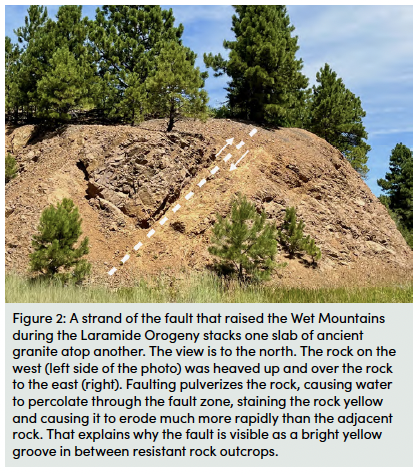
These rocks of vastly different ages lie next to each other thanks to the stacking of rock slabs along a fault zone that that developed at the interface between the Wet Mountains and the High Plains during the Laramide Orogeny (Figure 2). The stacking of crustal slabs raised these ancient rocks from their resting place deep below the surface to great heights in the growing mountain range. This mountain building is what led to Colorado’s oldest rocks being juxtaposed with much younger ones.
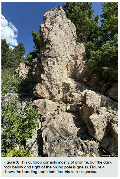 As the Bartlett Trail continues up some sharp switchbacks, examine the rocks at your feet. Do they all look like the granite seen at the High Plains overlook, or can you pick out some new rock types? Around a half mile further along the trail, you will reach a rock outcrop around 10 feet tall on the right side of the path (Figure 3).
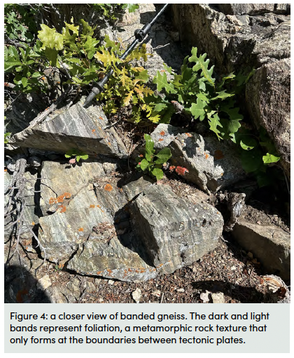
At this outcrop, two different rock types are found side-by-side, each one telling a different part of the region’s history. The 1400-million-year-old granites are a tan to salmon pink color, and have mineral crystals up to an inch across, like those seen at the High Plains overlook. The new rock type seen here is called gneiss, recognisable by its strong black and white banding (Figure 4). It is even older, checking in at 1700 million years. That makes it one of the oldest rocks in Colorado.
Gneiss is a type of metamorphic rock, formed when enough pressure and temperature are added to a rock that it can change into a new rock. The type of metamorphism needed to create gneiss requires high amounts of pressure in one primary direction that can squeeze the rock. This pressure can alter the minerals and cause them to separate and align, creating bands called ‘foliation’. The color difference is a difference in the mineral content, with white bands consisting of quartz and plagioclase feldspar, and the black bands of hornblende. This is like if you were to mix Playdough of many different colours and squashed them down on a table. This pressure would mean the Playdough spread out across the table, creating colourful bands if you were to look at a side profile of it.
Geologic settings that have a high enough pressure in one direction to create gneiss can only be found where two tectonic plates interact. The fact that the gneiss of the Wet Mountains was foliated around 1700 million years ago, much older than the Laramide Orogeny mountain building event, records an even older mountain building event that happened 1700 million years ago. This ancient plate tectonic boundary disappeared long ago, with the oceanic plate that converged with proto-North America in Colorado back then having been subducted into the deep Earth and the mountains formed by the subduction eroded away.
But the evidence that it once existed in Colorado is seen in the characteristic rocks of subduction zone settings that you see here. The pink granites were injected as molten magma into the gneiss 300 million years later. This outcrop displays good examples dark gneiss blocks that are ‘floating’ in a sea of pink granite. This texture shows that the granite injected later as a molten mass. This injection occurred during yet another tectonic event, but one that geologists have long found puzzling. There was no subduction in Colorado at that time, so they suspect the state experienced long-distance stress as a byproduct of subduction that was occurring in what is now Texas.
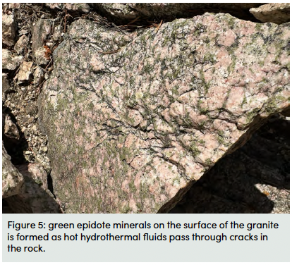
One color that might seem out of place on this rock outcrop is the grass green mineral covering the granite (Figure 5). This is epidote, a mineral formed from hot, mineral-rich fluids that travel through rock cracks. The presence of this epidote indicates that mineral-rich fluid percolated through the rock, likely during the later Laramide Orogeny.
The last 0.5 mile along the Bartlet Trail before reaching the boundary into the Greenhorn Mountain Wilderness takes you up to a small saddle on a ridge that presents a sweeping view westward into the heart of the Wet Mountains. Jagged outcrops of granite and gneiss dot the scenic view (Figure 6).
The rock to your left as you reach the saddle resembles the granite you saw earlier, but the individual white and pink mineral crystals are much larger, easily visible with your naked eye. This is a particular kind of granite called pegmatite granite. Pegmatite forms when the magma contains a lot of water. The presence of that water inhibits the formation of many crystals, concentrating crystal growth in fewer locations, which results in the formation of fewer, bigger crystals.
Thanks to the large crystal size, pegmatites offer a great opportunity to identify the different mineral constituents of granite. Try this yourself here! Some of the most common minerals here are two different kinds of feldspar, one salmon pink and the other white. If you bring a magnifying glass, you may be able to spot parallel lines in the mineral crystals that represent the crystal structure. The different colors are caused by small differences in the chemistry of the two feldspars. Both feldspars contain abundant silicon and oxygen, which bond together to form what are called “silica tetrahedra”, the building blocks of all feldspars and many other minerals. But, the pink feldspar contains potassium in its structure, making it what geologists call a potassium feldspar (surprise!). The white feldspar contains sodium (and a bit of calcium) and is called a plagioclase feldspar. 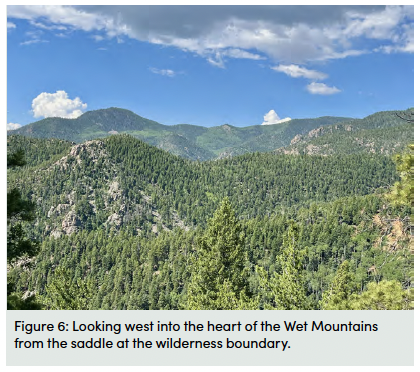
Silica tetrahedra form the foundation of many minerals, which are known as the silicate minerals, because oxygen is the most abundant element in the Earth’s crust (46%) and silicon is the second most abundant. The simplest kind of silicate mineral is quartz, which is pure silicon and oxygen, with no other major elements in its crystal structure. This outcrop contains lots of quartz, which is the translucent to milky white mineral that has no regular crystal shape and is found between the more rectangular feldspars. While pure quartz is clear, it can come in many different colours thanks to small quantities of other elements that may be trapped in its crystal structure. For example, amethyst is just quartz with small amounts of iron, whereas citrine is bright orange due to both iron and aluminum impurities.
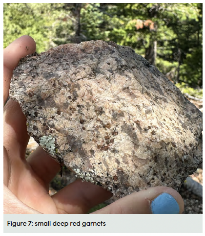
Also look here for micas, which are the shiny, silver-colored flat minerals that form stacks of parallel sheets that look like pages in a book. Quartz, feldspar, and mica are the main minerals in granite. But keep your eye out for the presence here of a more unusual pegmatite mineral – garnet. It is the very small, round mineral that is a deep shade of red (Figure 7). The presence of this garnet is another indication that the magma contained lots of hot water, as it is a sign of hydrothermal (meaning hot water) alteration either during formation of the pegmatite granite or during later metamorphism.
If you are ambitious (and if you’ve shuttled a car to the Bartlett Trail’s western trailhead), you can carry on, ascending to the crest of the Wet Mountains. Almost to its end, the rocks you’ll pass are similar to those you’ve seen thus far. But the boundary into the San Isabel National Forest is a nice place to turn around if you are out for a more leisurely day hike. As you descend the way you came your elevated perch here in the Colorado Rockies provides you with panoramic views of the vastness of the High Plains far below. It’s a great opportunity to ponder how profoundly geologic history shapes our everyday lives, as it dictates the landscape we navigate and the mineral resources at our disposal. As the historian Will Durant famously remarked: “Civilization exists by geological consent, subject to change without notice”.