Just about a half mile along West Spanish Peak Trail, the trail forks. The left path leads to the Vista Point Overlook where you get a stunning view of the Sangre de Cristo Range to the west. The distinct deep, red-coloured rocks that make up the Sangre de Cristo Mountains are best seen here along Highway 12 , where they stand in steeply tilted layers oriented north-south.
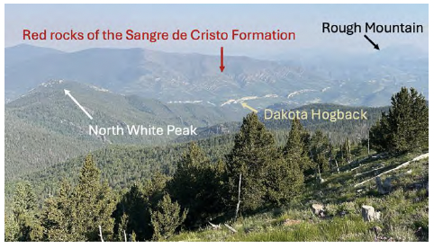
These red sedimentary rocks are mostly sandstones and conglomerates composed of material that was carried by ancient rivers that once drained the “Ancestral Rocky Mountains”. The Ancestral Rockies were formed around 300 million years ago as the North American tectonic plate collided with Africa and South America to form the supercontinent Pangaea. The red color in these rocks is caused by the chemical reaction of water with iron-bearing minerals in the rock. This reaction produces the iron-oxide mineral hematite. It’s the exact same chemical reaction that alters bare metal exposed to rain water — in other words, the rocks are rusting!
As you bring your gaze closer, you see the valley traversed by Highway 12 and on the near side of that, up pops a fin of tan rock, which is the Dakota Hogback. A hogback is a long, narrow ridge of resistant rock, making it look like the razorback of a wild hog. While this may look like one of the dikes that make the Spanish Peaks region so famous, it is sedimentary rock of the Dakota Formation. Around 100 million years ago, much of eastern Colorado was part of the Western Interior Seaway, a shallow ocean that ran through the middle of North America. The erosion-resistant Dakota Sandstone was deposited along the beach of this ancient sea. The Dakota Hogback is a prominent feature that trends north-south with few gaps all the way from New Mexico to Wyoming. As you travel west across the High Plains of Colorado, it marks your entry into the Rocky Mountains (see the Dikes Trail Guide for more information on this feature).
Both the sedimentary rocks of the Sangre de Cristo Formation and the Dakota Hogback were once deposited horizontally in flat layers, like you would imagine the sand along a beach. However, these layers now stick up out of the ground in nearly vertical fins. For this to happen, a mountain building event had to tilt all these rock layers, displacing them from their originally horizontal position.
The tectonic event that built ranges like the Sangre de Cristos and the Wet Mountains (visible to the north of La Veta) began stacking slabs of rock one atop the other about 70 million years ago. It is called the Laramide Orogeny (orogeny is just a fancy name for a mountain-building episode). The trigger was the sinking of an ancient tectonic plate, called the Farallon Plate, beneath the North American Plate as the two plates approached one another. The Farallon disappeared beneath the North American Plate off the coast of California. The compression the two plates exerted on each other caused the rocks above them to crunch together, forming the Laramide Rockies. The once horizontal layers of ancient sedimentary rock were steeply tilted, and powerful rivers flowed through the mountains, sculpting them into peaks and valleys through erosion.
The central portion of the Farallon plate, at the latitude of California, has been consumed and no longer exists, but its most northern and southern fragments persist today. The northern fragment is known as the Juan de Fuca Plate, whose movement underneath the Pacific Northwest produces spectacular volcanoes like Mount Saint Helens, Mount Rainier, and Mount Hood. The southern fragment forms the modern Cocos Plate, which slides beneath central Mexico and Central America, producing a chain of volcanoes that stretch from Mexico City through Costa Rica.
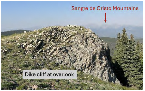
Take a look at the large mineral crystals in the cliff that makes up the Vista Point Overlook. This is one of hundreds of igneous dikes that originates from West Spanish Peak. Igneous rock forms from the cooling of once molten magma; as it cools, crystals like the ones you see here form and grow together. It is this texture of interlocking crystals that reveals the magmatic origins of the Spanish Peaks. As you continue along the trail, you will see several more of these dikes, all of which radiate away from West Spanish Peak like spokes on a wheel. The main magma body underlies West Spanish Peak, with these many dikes shooting outward in all directions. When molten, these tabular dike magmas were pressurized, so they injected themselves into the surrounding sedimentary rock wherever they found a weakness they could exploit.
The sedimentary rock that the dikes cut through is the Huerfano Formation, which consists of rock debris that was eroded from the Rocky Mountains as they eroded as they were uplifted during the Laramide Orogeny.
The Huerfano Formation was never buried deeply after its deposition during the Laramide Orogeny, Such burial is necessary for loose sediments to be cemented together into sedimentary rocks. Because the Huerfano Formation was not well cemented, it erodes quite easily. As you walk through the forested area north of Vista Point meadow, take note of the loose rocks below your feet, which were derived from erosion of the Huerfano Formation and the dikes that cut through it. Along parts of the trail, the rocks are strikingly round, like those you might find on a riverbed or on a cobble beach. Those were all derived from the Huerfano Formation. You’ll likely also spot some jagged rocks with sharp edges, almost like broken plates. The rounding, color, and mineral content of these smooth versus jagged rocks tells us they are formed from very different processes.
Rocks become rounded, it by banging against each other as they are transported from where they were broken off their parent rock body during erosion to their final resting place in a sediment deposit. Imagine a rock that has been bumping along a riverbed — it will begin to round into a more spherical shape. The farther it travels, the rounder it gets. The red rocks of the Sangre de Cristo Formation that comprise the modern range of the same name consist of conglomerates that contain cobbles and pebbles of
rocks that were rounded while being transported in rivers that drained the Ancestral Rockies (~300 million years ago). Likewise, these cobbles derived from the Huerfano
Formation were rounded as they tumbled down steep rivers that drained the Laramide Rockies (~70 million years ago). In fact, because the Laramide Sangre de Cristo mountains are composed largely of the Sangre de Cristo Formation, which contains cobbles rounded by transport in those ancient, 300-million-year-old rivers, when those later mountains were eroded, many pre-rounded cobbles were liberated from the formation and experienced a second trip down a new river. That is a big reason why so many of the rocks you see here are so impressively well rounded — they’ve gone through the rounding process more than once!
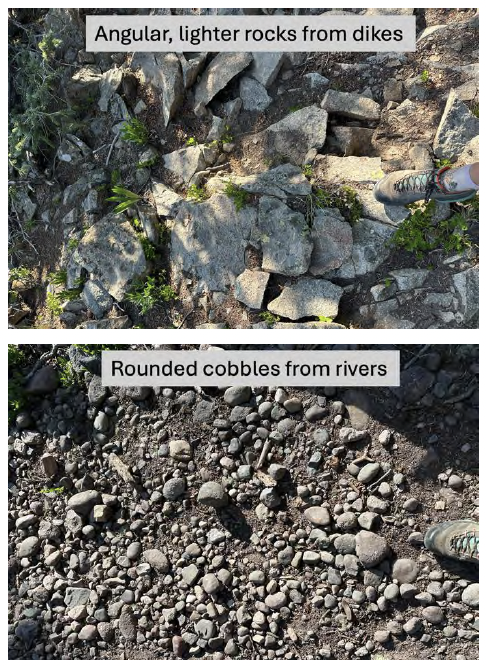
The composition of these rocks varies a lot. Some are shiny and clear, which is a rock called quartzite. Some may have bands of black and white throughout, which identifies them as gneiss, a metamorphic rock. And some may be made up of sand grains or larger, which are sedimentary rocks. Their
compositions record what rock types made up the peaks of both the Laramide Rocky Mountains and their predecessors, the Ancestral Rockies. Now that they have been pried out of the Huerfano Formation by modern erosional processes, they are set to begin their third trip through the sedimentary cycle, as gravity tugs them inexorably downhill, where they will inevitably end up in the Apishapa River and roll slowly, one flood at a time, down it to its confluence with the Arkansas River far to the east on the High Plains.
Note of the stark contrast between the rounded cobbles and the more jagged rocks along the trail. Their sharp nature tells us that they were not transported far at all, meaning they haven’t been rounded by banging into other rocks along a river bed. Most of these jagged rocks contain large, rectangular, white crystals of the mineral feldspar; few of the rounded cobbles display that composition.
Instead, compare their textures to those of the dike you saw at the Vista Point Overlook; we bet you’ll see that they match. These are shards that have broken off nearby
outcrops of the radial igneous dikes. If you keep a sharp eye out as you traverse the trail, you’ll spot areas dominated by the jagged dike pieces. This tells you that you are likely close to a dike outcrop — keep your eyes peeled and you may well see one rising in the trees nearby.
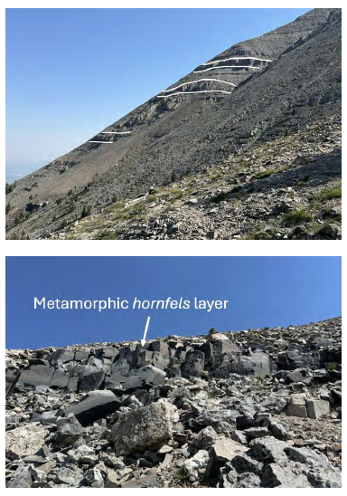
As you reach the treeline, try and pick out the black rock bands that wrap around West Spanish Peak. These are layers of sedimentary rock. You may ask, why are there sedimentary rocks if West Spanish Peak is an igneous magma chamber? When the hot magma intruded into the rocks of the Huerfano Formation 24 million years ago, the surrounding sediment was exposed to this heat. Almost like baking clay to make tougher terracotta, the heat from the magma chamber cooked these sedimentary rocks, making them more resistant to erosion than the rest of the formation that wasn’t cooked (the part you saw the cobbles from on the forest floor) and preserving them on the side of the mountain. This is a form of metamorphism, the process of adding heat and/or pressure to rocks that changes their mineral to form a new type of rock. In the case of the black bands around West Spanish Peak, these were once mudstone that has now been metamorphosed into a rock called ‘hornfels’.
 As you start the steep part of the ascent to West Spanish Peak, the trail becomes much less consolidated, with the trail winding its way through the many large boulders that make up much of the peak. The change in trail conditions is in part due to the high elevations that do not allow for much vegetation to grow, but it also depends on the geologic processes going on. The ridgeline that continues up to the top of West Spanish Peak roughly follows another igneous dike.
The rocks that are at high elevation here are highly prone to break down by the harsh conditions. High and dry environments will experience big swings in temperature from being baked in the high intensity sun during the day, to dropping below freezing at night. This means that the rocks exposed at the surface will expand and contract due to temperature fluctuations much more than rocks that are further away from the surface. This difference in heating and cooling makes outer layers of the rock break off from their original position. Another process that leads to these large scree slopes is called frost shattering. When it rains atop the Spanish Peaks, water can filter down into tiny cracks between rocks. During the nights when it reaches freezing temperatures, ice forms in these spaces. Ice will take up more space than liquid water as it expands, leading to expansion of the cracks it fills. Over enough time, these cracks link up and blocks of rock are quarried out of the bedrock, forming the talus slope you are ascending.
The first thing you should do at the top is give yourself a big pat on the back — West Spanish Peak is a steep trail! Next, take in the surroundings! Try and count the dozens of radial dikes that you can see sticking up as fins that radiate in all directions from the summit where you stand, like spokes from the hub of a wheel. As you have walked the whole trail, you have crossed multiple dikes, but what do they tell us about the history of the region?
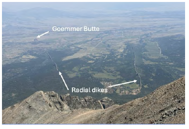
The Spanish Peaks themselves were formed around 24 million years ago as magmatic bodies deep below Earth’s surface. The high pressures of the magma chambers meant that the molten rock wanted to escape, and it did so through weak spots in the surrounding rock. It’s the escaping magma from West Spanish Peak that led to the hundreds of dikes that now radiate out from it. At the top of West Spanish Peak, you can see parts of the magma chamber that are in place (i.e. have not been broken off or tumbled downhill to form loose scree). Many of these are hard, resistant rock, leading to the formation of the famous fins that stick up throughout the landscape.
Beneath the surface during this time, the crust beneath Colorado was experiencing a switch from being compressed (compression is what triggered the Laramide Orogeny) to extending. This change in the stress field was accompanied by a period of extreme volcanism that is called the ignimbrite flare-up. Many notable Colorado geologic features, such as the ash beds that formed the Wheeler Geologic Site near Creede, and the massive pile of lava and ash beds that built the San Juan Mountains were erupted from those volcanoes. The extension pulled the crust apart and stretched it like pulling taffy apart. But rocks can’t stretch like taffy can, so the stretching was accomplished by movement on a series of faults, which dropped a block of rock down between them to create the upper Arkansas river valley from Leadville to Salida and the San Luis Valley, as well as the Rio Grande river valley flowing south through New Mexico. This is a geological rift valley, similar to the famous East African Rift Valley, which is named the Rio Grande Rift after the river.
The Spanish Peaks and dikes are not the only evidence of Huerfano County’s hot history. More evidence of this volcanic period is found in some of Huerfano County’s most iconic features. Silver Peak, Goemmer Butte, and the White Peaks were similarly formed as igneous bodies below the former surface. You might ask “where are the volcanoes that these magma chambers once fed?” — We don’t know! There is no evidence that the Spanish Peaks magma chambers ever resulted in volcanic eruptions, and while it is possible that they once did, the rocks that could reveal this story are lost to erosion.
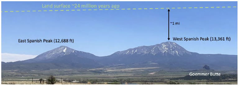
The reason all these solidified magma chambers that formed and cooled deep below Earth’s surface now form mountains that tower above the High Plains below is that massive amounts of erosion has removed the softer sedimentary rocks that once surrounded and covered them. Think about the cobbles you saw along the forest trail that are all that’s left of the Huerfano Formation and you get a good idea of how comparatively easily these rocks could be removed. By contrast, the solidified magma chambers and dikes consist of granite, a tough rock that resists erosion.
This erosional event took place between 20-5 million years ago, and the more erosion occurred, the higher the peaks stood above the surrounding plains. Erosion is continuing today, and at this point it has removed at least 2 miles (!) of soft sedimentary rock. As you stand on West Spanish Peak and observe the flat plains far below, imagine the presence of that 2 miles of rock filling the vast plain up to your present elevation and another mile above you. That is a mind-bogglingly enormous volume of rock that has been removed and lost to time!