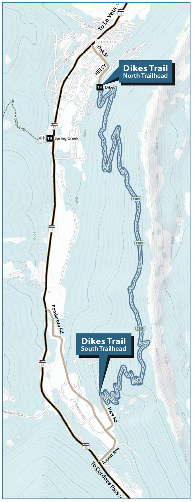
 Most people start the Dikes trail at the north trailhead, which is directly above Cuchara. You can shuttle a vehicle to the south trailhead to do a one-way walk of the whole trail, or you can make it an out-and-back hike to the top of the ridge and return to the north trailhead.
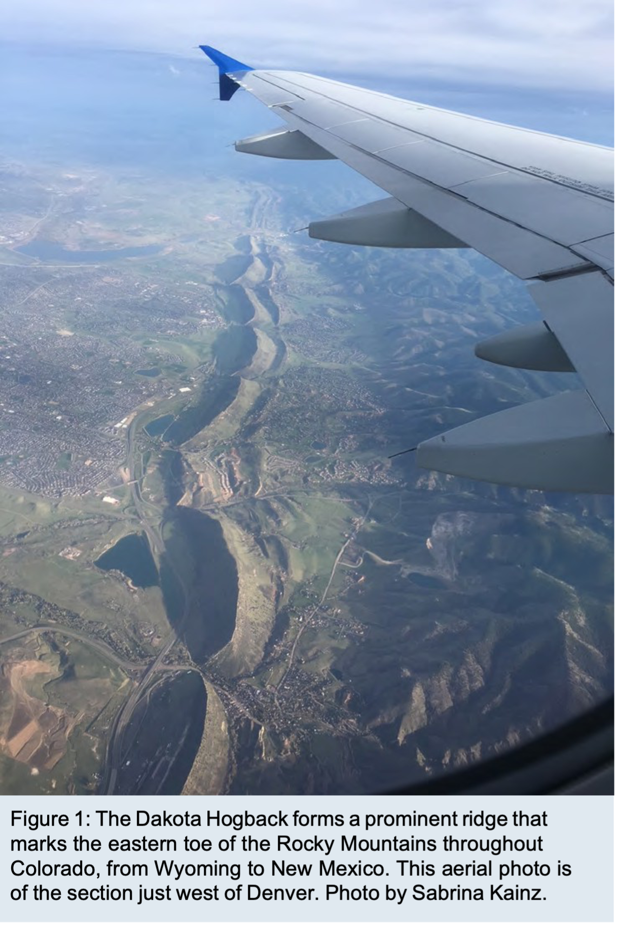
Starting from the north trailhead, you traverse through a series of switchbacks as you gradually ascend the forest-covered west flank of the Dakota Hogback (Figure 1). A hogback resembles a dike, but instead of being an igneous rock that intruded as liquid magma, it consists of sedimen-tary rock layers that were originally deposited as horizontal sheets of sediment and were subsequently tilted steeply by tectonic activity. Colorado’s Dakota Hogback was tilted up 65 –70 million years ago, during formation of the Rockies.
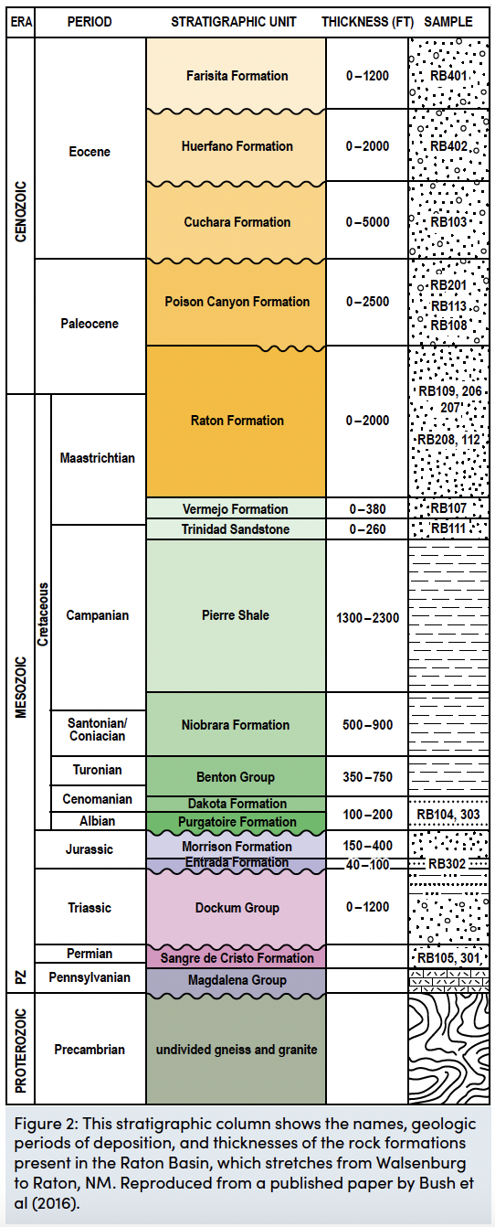 Because of the up-to-the-west rock tilt, progressively younger rocks are exposed as you travel from west to east. Figure 2 lists the order of rock layers here, with the oldest at the bottom and youngest at the top. There are no exposed rock outcrops on this first part of the trail because it crosses the Morrison Formation, which consists mainly of mudstone, a rock type that is easily eroded. It is older than the Dakota Formation, the rock unit whose prodigious resistance to erosion produced the hogback.
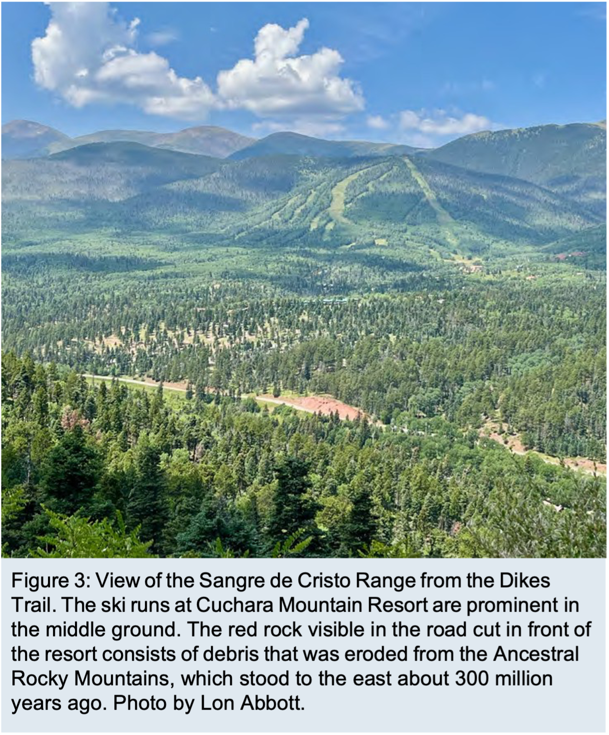 The higher you climb, the better the view of the Sangre de Cristo mountains to the west becomes (Figure 3). Those mountains are built of the even older Sangre de Cristo Formation and Dockum Group sedimentary rocks (Figure 2), which are bright red in color. That color isn’t obvious across most of the vista because of the vegetation cover, but it is readily apparent in a road cut along Highway 12 that is visible in front of the Cuchara ski area from this vantage point (Figure 3). These rocks tell their own fascinating story of landscape change: they consist of debris that was eroded from an earlier mountain range that once stood to the east, on what is now the pancake-flat Great Plains.
But 300 million years ago, that area was uplifted by faults to form the Ancestral Rocky Mountains; the area where the modern mountains stand was at that time a basin that received the debris shed from the range that rose to the east.
Although there are no outcrops of Morrison Formation as you zigzag up the hogback’s west slope in the first mile of trail, you periodically pass huge sandstone boulders that have tumbled down from the Dakota Formation above.
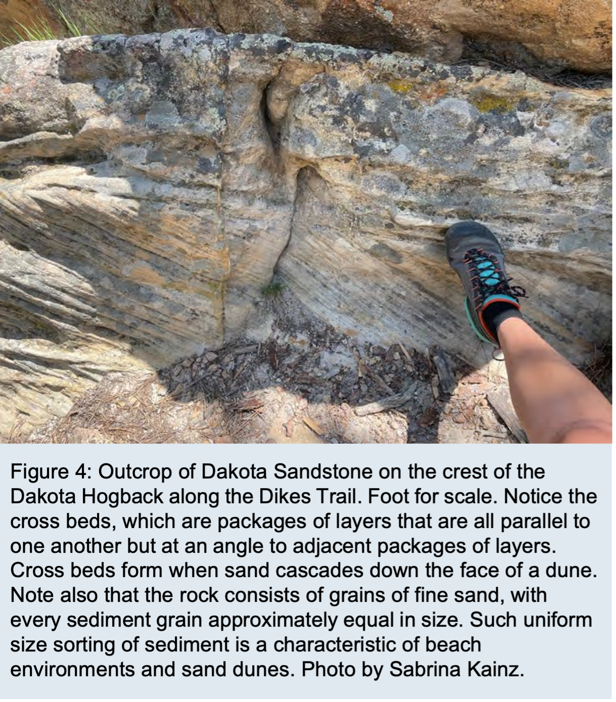 If you examine them, you’ll see that they consist of many layers, most composed of uniformly sized sand grains, but a few containing larger pebbles. The last big switchback bends to the right about 400 vertical feet below the ridge crest, after which the trail heads south-southeast for the next mile, executing a rising traverse that brings it ever closer to the ridge crest. The trail takes one more left-bending switchback to head east, towards the ridge crest, for a few hundred yards and then bends back right to resume its southward trajectory. Take the short (100 yards) spur trail to a saddle on the ridge crest where the main trail bends back to the right. This is the trail’s geologic highlight, where you can examine good outcrops of Dakota Formation sandstone (Figure 4) and are treated to a great view of the White Peaks to the east, across the valley of White Creek (Figure 5).
The Dakota here consists of layer after layer of uniform sand grains, just like those you saw on the tumbled boulders during the ascent. Several packages of parallel layers are visible here, with the layers of one package inclined at an angle to the layers in adjacent packages (Figure 4). This is a characteristic called “crossbedding”; it is produced when sand piles up in a mound, called a “dune” 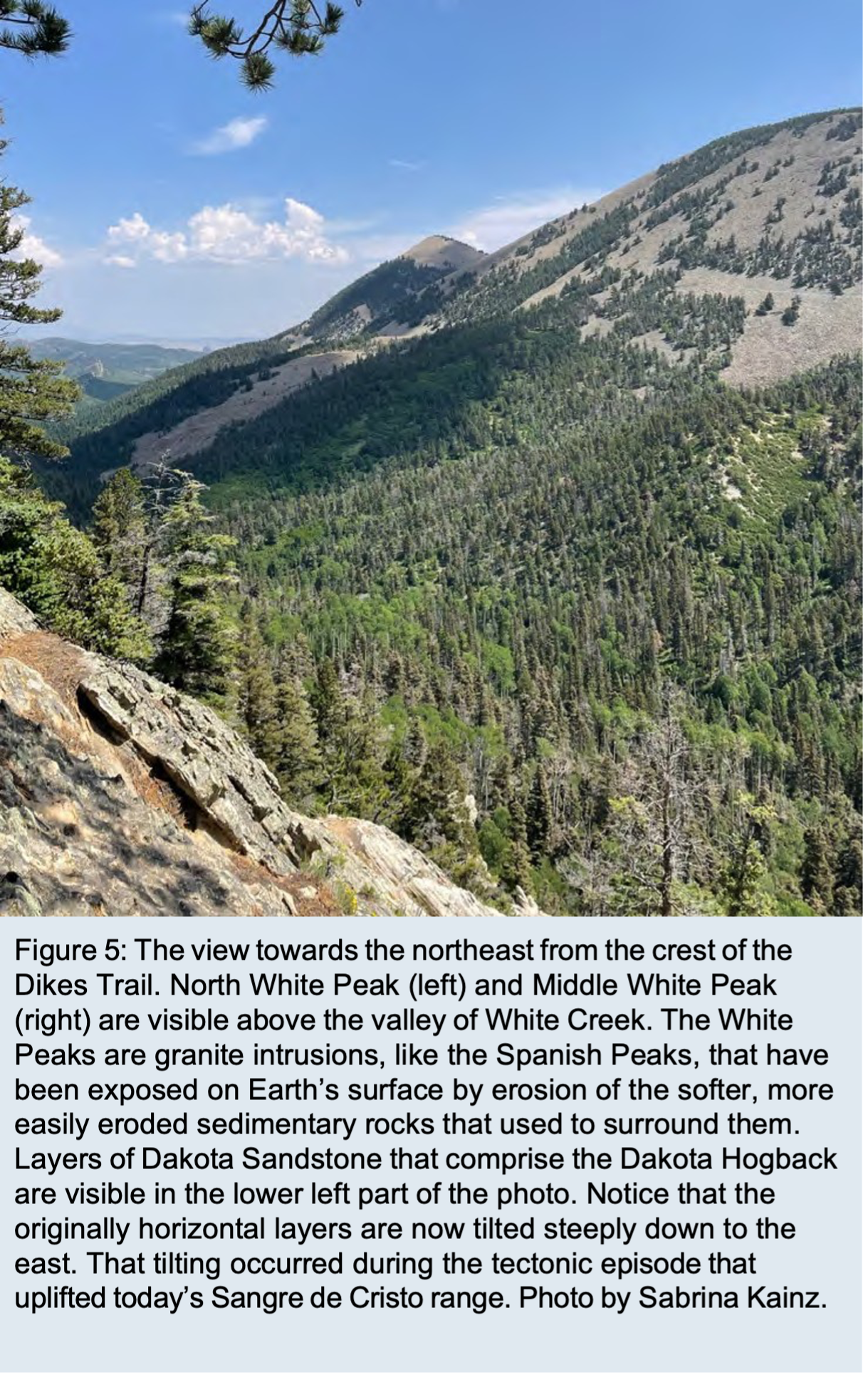 (desert sand dunes are great examples, but dunes form in other environments as well). As wind or water currents pile sand up at the top of the dune it periodically cascades down the lee side, depositing an inclined layer. The next sand cascade forms a layer atop the first, and so on to form the packages of parallel layers. In this manner, the dune migrates, and when the next dune passes by it deposits a similar set of layers on top, which form the overlying package.
The dunes that formed these cross beds were small fields of sand dunes on the landward side of a beach, similar to the back-beach dunes one sees in innumerable beach environments today. One good example is the Oregon Dunes National Recreation Area. The uniform size of the sand grains you see here is also a typical feature of modern beaches — they are typically composed of billions of similarly-sized sand grains because the steady, rhythmic wave energy efficiently sorts sediment sizes, leaving only sand on the beach.
Geologists use clues like the cross beds and the good size-sorting of the sand displayed by modern beaches to recognize that the Dakota represents an ancient beach; similar processes produced similar sediment characteristics throughout Earth history. The pebble layers you saw on the Dakota boulders down the slope were deposited by rivers that emptied to the sea in this coastal environment.
It may seem amazing that Colorado, the highest-elevation state in the Union, was once beachfront property, but geologic processes have the luxury of vast expanses of time to completely transform each landscape over and over again. Sea level is never steady, it is always rising or falling. It was on the rise 100 million years ago when the Dakota beach sands covered Cuchara; a vast inland sea covered the mid-continent of North America, from Texas to Canada’s Northwest Territories. That sea, which geologists call the Western Interior Seaway, split the continent into gigantic eastern and western islands. Cuchara occupied a beach on the east coast of the western island.
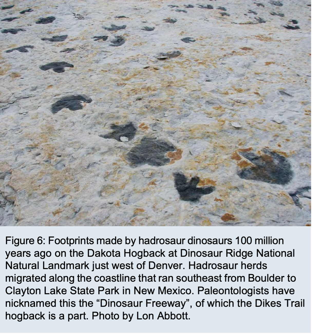 Herds of dinosaurs wandered past Cuchara on their seasonal migrations along the coastline from Boulder, in the north, to New Mexico’s Clayton Lake State Park in the south and back again on what paleontologists have nicknamed the “Dinosaur Freeway”. We haven’t seen any dinosaur footprints embedded in the Dakota Hogback here in Spanish Peaks country, but elsewhere in the region some very impressive tracks are preserved. Once again, Cañon City is the closest place to see these marvelous relics of the past. Skyline Drive provides a short, spectacular auto tour of the Dakota Hogback there, including footprints of ankylosaur dinosaurs. If you are heading north, Dinosaur Ridge near Denver has what is probably the single best exposure of dinosaur trackways on the Dinosaur Freeway (Figure 6), and if you are southbound, check out the tracks at New Mexico’s Clayton Lake State Park.